|
 Aeronautical Surveys at Multiple Airports for the FAA WAAS, Various Locations Throughout the United States—2005-2012 (current).
The Wide Area Augmentation System (WAAS) program office of the Federal Aviation Administration (FAA) was tasked with producing aeronautical
survey data sets for a vast number of airports across the country.The survey data and deliverables are ultimately used for the development
of approach and departure procedures for arriving and departing aircraft.
In 2011, Woolpert received a service excellence award from The Management Association for Private Photogrammetric Surveyors (MAPPS)
for the program work completed.
Aeronautical Surveys at Multiple Airports for the FAA WAAS, Various Locations Throughout the United States—2005-2012 (current).
The Wide Area Augmentation System (WAAS) program office of the Federal Aviation Administration (FAA) was tasked with producing aeronautical
survey data sets for a vast number of airports across the country.The survey data and deliverables are ultimately used for the development
of approach and departure procedures for arriving and departing aircraft.
In 2011, Woolpert received a service excellence award from The Management Association for Private Photogrammetric Surveyors (MAPPS)
for the program work completed.
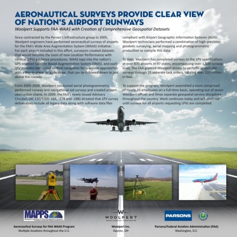
Parsons Infrastructure Group, Inc. works with the FAA through their Technical Support and Services Contract (TSSC-III).
Woolpert was contracted to complete the surveys the WAAS program office needed to produce Localizer Performance with Vertical Guidance (LPV)
procedures in support of the Space Based Augmentation System (SBAS). To date, Woolpert has assisted in completing surveys to the LPV survey
specifications nearly 1,200 airports in 47 states.
The project deliverables have followed AC-150/5300 series guidelines as they have evolved. Each airport required complete surveys,
including geodetic control establishment, aerial photography acquisition and compilation, accurate safety-critical runway and NAVAID surveys,
obstruction mapping and reporting, digital data files in a variety of formats and supporting reports and documentation as required to assist in
government verification of the data delivered.
|
|
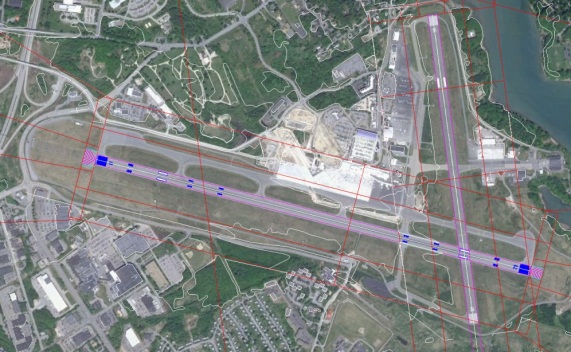 Aeronautical Survey for Portland International Jetport (PWM), Portland, ME—2011.
Under contract to DeLuca-Hoffman Associates, Inc.,
Woolpert performed a complete aeronautical survey as required for procedure development into the Runway 11/29 and 18/36 approaches at Portland
International Jetport in Portland, Maine. The survey followed the specification outlined by the FAA for completion of an Airport Airspace Analysis
Survey for runway with Vertical Guidance. The work and deliverables are compliant with the standards as required in FAA Advisory Circular 150-5300 16A,
17B and 18B. Woolpert’s responsibilities included: Photo control survey; Collection of Imagery that was 17B compliant; Georeferencing of AC-17B compliant
Imagery; Runway, Navaid and Obstruction Survey; Stereo analysis of features that penetrate the OIS surfaces; Asbuilt surveys (post construction) of runways
and NAVAIDS; Obstruction analysis per AC-18B specification; Development of Orthophotography per AC-17B specifications; Development and delivery of FAA compliant
GIS data file; and Completion of the project through the FAA’s Airports GIS web portal.
Aeronautical Survey for Portland International Jetport (PWM), Portland, ME—2011.
Under contract to DeLuca-Hoffman Associates, Inc.,
Woolpert performed a complete aeronautical survey as required for procedure development into the Runway 11/29 and 18/36 approaches at Portland
International Jetport in Portland, Maine. The survey followed the specification outlined by the FAA for completion of an Airport Airspace Analysis
Survey for runway with Vertical Guidance. The work and deliverables are compliant with the standards as required in FAA Advisory Circular 150-5300 16A,
17B and 18B. Woolpert’s responsibilities included: Photo control survey; Collection of Imagery that was 17B compliant; Georeferencing of AC-17B compliant
Imagery; Runway, Navaid and Obstruction Survey; Stereo analysis of features that penetrate the OIS surfaces; Asbuilt surveys (post construction) of runways
and NAVAIDS; Obstruction analysis per AC-18B specification; Development of Orthophotography per AC-17B specifications; Development and delivery of FAA compliant
GIS data file; and Completion of the project through the FAA’s Airports GIS web portal.
|
|
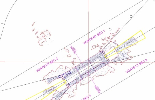 Aeronautical Obstruction Mapping, Sanford Regional (SFM) and Millinocket (MLT), Maine— for Portland International Jetport (PWM), Portland, ME—2011.
Woolpert was contracted to provide airport obstruction mapping compliant with Federal Aviation Administration (FAA) and National Geodetic Survey (NGS) standards
and with guidelines for Instrument procedure Development. The standards and guidelines – ACs 150/5300-16A, 17B and 18B – comprehensively addressing the surveying,
mapping, and infrastructure data collection and attribution requirements that support precision approach analysis, design, and certification. Woolpert’s
responsibilities included: Photo control survey; Generation of Obstruction Identification Surfaces (OIS); Runway, NAVAID and Obstruction Survey; Survey of
clearing limits for removed obstacles; Asbuilt surveys (post construction) of runways and NAVAIDS; Obstruction analysis which provided all penetrating
features to be used for a clearing plan; Development of orthophotography; Development and delivery of FAA compliant GIS data file; and Completion of the
project through the FAA’s Airports GIS web portal.
Aeronautical Obstruction Mapping, Sanford Regional (SFM) and Millinocket (MLT), Maine— for Portland International Jetport (PWM), Portland, ME—2011.
Woolpert was contracted to provide airport obstruction mapping compliant with Federal Aviation Administration (FAA) and National Geodetic Survey (NGS) standards
and with guidelines for Instrument procedure Development. The standards and guidelines – ACs 150/5300-16A, 17B and 18B – comprehensively addressing the surveying,
mapping, and infrastructure data collection and attribution requirements that support precision approach analysis, design, and certification. Woolpert’s
responsibilities included: Photo control survey; Generation of Obstruction Identification Surfaces (OIS); Runway, NAVAID and Obstruction Survey; Survey of
clearing limits for removed obstacles; Asbuilt surveys (post construction) of runways and NAVAIDS; Obstruction analysis which provided all penetrating
features to be used for a clearing plan; Development of orthophotography; Development and delivery of FAA compliant GIS data file; and Completion of the
project through the FAA’s Airports GIS web portal.
|